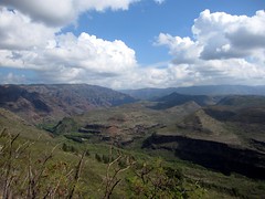
 Waimea Canyon is one of Kauai's many natural wonders. Stretching for over 10 miles from north to south, and over 3500 feet deep, it's highly reminiscent of the Grand Canyon, just not as big. Waimea Canyon State Park lines the western edge of the canyon, and at the north end, Koke'e State Park stretches another 4 or 5 miles to the north and east, covering the plateau at the top of the Na Pali coastline ridge. Unfortunately, with the steep mountain range along the Na Pali Coast preventing direct travel by car, we had to nearly circumnavigate the island to get there -- a 2 hour drive (over 70 miles) just to travel 11 miles, as the crow flies.
Our plan was to drive to Koke'e State Park, stopping at the canyon overlooks on the way, and then hike one of two loop trails: one went out to the ocean (halfway down the Na Pali coastline) and back, and the other ventured into the Alaka'i Swamp, giving us a taste of a remote rainforest near the wettest spot on earth. We couldn't decide which we preferred. While the coast loop would certainly have better vistas, the Alaka'i Swamp had the potential to be a more unique experience.
The weather was looking pretty good as we made our way to the canyon mouth on the south end, although it got cloudier as we continued north. There are numerous overlooks along Waimea Canyon Drive as you ascend the western canyon wall, with incredible views. Sadly, my photos show much more haze than I remember, and I apparently need to learn how to better use my camera's panorama feature, since there are all kinds of weird light and perspective distortions going on in the series I took. Anyways, we stopped at 3 or 4 overlooks, but I was getting nervous since more and more clouds seemed to be rolling in. I knew, based on our experiences earlier in the week, that rain clouds were likely to start rolling in at any time in early afternooon. If we didn't get going, we weren't going to see anything on either of our planned hikes..
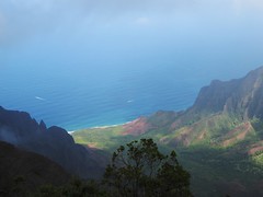 We made our way toward the end of the road, which is home to the Kalalau Beach Lookout and the trailhead for the swamp loop. The lookout was beautiful, it was sunny at the shoreline and and we were just under the cloud deck that formed as the moist ocean air was forced up the valley wall. You could actually watch this happening. As we proceeded to the trailhead for the Alaka`i Swamp loop, we ascended into the clouds and everything was completely socked in. The parking lot at the end was also completely full, and overflowing well down the road. We decided to turn around and take the coastal loop.
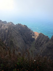 As we parked at the other trailhead and started down the trail, it continued to get more cloudy. It was clear that if we didn't hurry, we weren't going to see anything, and a hiker coming the other way told us it was clouding up fast. We booked down the 3 mile Awa`Awapuhi Trail in just over an hour, and got to the viewpoint with about 5 minutes to spare. We only just barely got to look down into the Nu`alolo Valley before our viewpoint was also completely fogged in. There was nobody else there, and it was really rather serene and tranquil -- except for the helicopters buzzing around us every 10 minutes. We ate our lunch as the mist enveloped us, while listening to the helicopters zooming in and out of the valleys below.
After lunch we decided to turn back to the car instead of completing the loop, since there was nothing to see in the fog anyways. Good thing, too, since it started pouring rain after about 15 minutes. The rain was off and on for most of the climb back, through the muggy rainforest. We got back to the car and decided to try going back to Waimea Canyon, hoping the weather would be better further south and inland.
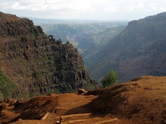 Sure enough, it was, and we followed a combination of trails to a cliff overlook, and the top of Waipo'o Falls. After following a gravel road for a while, we used a combination of the Cliff, Black Pipe, and Canyon Trails, to get to the falls. The route is very interesting, with the first section through the woods and then the next session along the top of an open ledge, with excellent views of the canyon. These 800-foot falls are visible from many of the Waimea Canyon lookouts, but the only trail goes across the top. Before the stream makes its plunge over the falls, it wends through a lush and tropical garden full of ginger plants. The flowers and fragrances were lovely, even if the plants are considered invasive and are taking over the whole area. There is not much to see of the actual falls from the top, but there is a great view of an interesting natural rock formation on the shoulder of the Ka`ou ridge.
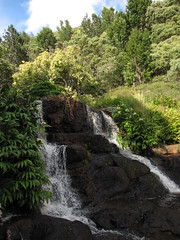 Since it wasn't obvious where to cross the stream, and it was going to be getting dark soon, we decided to head home. Rather than stopping for dinner on the way, we drove home first to get cleaned up. For dinner we tried Pau Hana Pizza in Kilauea, next door to the Lighthouse Bistro and recommended in several guidebooks. There were a couple of tables outside, but not much of a dining area, so we decided to get takeout and bring it back to the condo. The menu had some interesting flavor combinations, and the pizza was generally pretty good, but kind of expensive and not terribly memorable.
Reminder: Edith and Brian each have more photos and videos in their Flickr albums. There's no room for them all on the blog!

No comments:
Post a Comment