Monday, October 26, 2009

Hawaii Diiary: Volcano

Sorry this took so long. We packed a lot of stuff into this day, and there were a lot of photos, and I guess I like to write (and/or I need an editor). For those of you with short attention spans, here is the Twitter-friendly version: "We drove, we saw petroglyphs, we walked on a volcano (it rained). We drove, it rained, we saw lava, we ate dinner, we drove." Is that less than 140 characters? Now go look at my pretty pictures (more than I posted on this entry) and bad amateur video.

Room with a view 
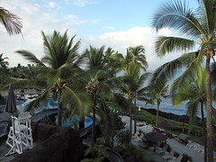
We woke up on Thursday to find that our "garden view" hotel room actually overlooked the pool, with the ocean in the distance. The hotel's two pools were large and connected, with grottos, kiddie beaches, and a water slide. Very impressive. Unfortunately, we didn't have time to enjoy it. More on the hotel in a later entry.

On the road to the volcano 
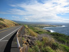
After grabbing coffee and a muffin, we left for Hawaii Volcanoes National Park, a third of the way around the island on the south side. Even though it was only 80 miles, it would take about two hours to drive there. The road is only two lanes, with some towns and winding sections. We were delayed at the start by the traffic jam going into the school, but made pretty good time once we got through the first 30 slow miles. There are some very scenic parts of this drive, especially northeast of Naalehu, and not much else.

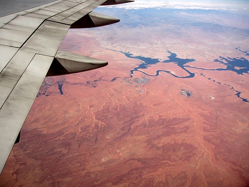
The weather was looking good until we reached the park entrance, at about 4000 feet above sea level. The most popular part of the park rests on the southeast shoulder of Mauna Loa, stretching from the area around Kilauea Caldera down to the ocean. This shoulder, combined with the predominant northeast winds, means that it is rainy and tropical on the east side (and on top), and dry and desert-like on the west side (which we just drove through). We brought our raincoats, but only shorts and no change of clothes. I hoped we wouldn't get too cold or wet.

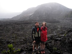
An unfortunate part of our trip was that we were only spending two full days on the big island. One of those days would be for seeing the volcano, and we knew that wasn't really long enough to give it a fair shake, but we would at least get a taste of it. The more accessible part of the park is a road around the Kilauea Caldera (Crater Rim Drive), and a road that threads south towards the ocean, through a series of old crater sites on the way (Chain of Craters Road). Here is a map. (1.8MB PDF) However, half of Crater Rim Drive was closed due to volcanic activity in the caldera, which was spewing toxic fumes in the air, so the tour was mostly reduced to an out-and-back trip. Aside from the Kilauea Caldera activity, there was also an active eruption at the Pu'u 'O'o site on the eastern edge of the park. This area was also closed, but it was a long hike from the road as well, so we were never going to have a chance of seeing it anyways. There was some lava flowing into the ocean from Pu'o 'O'o, but the best (and only officially sanctioned viewing spot) was outside the park and accessed from the east side in Kalapana, which is about an hour's drive. This meant we had to plan to get out of the park by about 4:30 at the latest, since the sun set at about 6:30, and we wanted to get to the lava viewing before then. My plan was to start at the entrance and work our way down to the ocean, seeing the sights along the way. Then we'd leave for Kalapana.

It was almost 11 AM when we arrived. After picking up some lunch items at the Volcano general store, we stopped at the park visitor center, where we learned that there would be a ranger-guided hike around and through Kilauea Iki Crater at 1:00. This was a hike we wanted to do anyways, since it was a chance to get out and explore some stuff in only a couple of hours, so we rearranged our schedule to be back at that time.

Petroglyph 
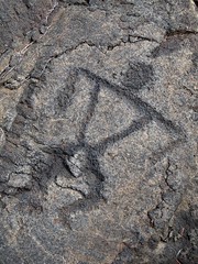
We first drove most of the way to the end of the Chain of Craters Road, and the weather cleared up nicely as we approached the ocean. There is a cliff along the way, which is covered with the remnants of lava flows from the 1970s. We stopped at the Pu'u Loa Petroglyphs. Here, each generation of the ancient Hawai'ians would carve symbols in the lava rocks and deposit the piko (umbilical cord) of their kids in the pukas (holes), hoping that the spirits would bless their child with a long and prosperous life. This is supposedly one of the largest and most concentrated areas of petroglyphs in Hawaii.

After viewing the petroglyphs, we worked our way back towards the Kilauea Iki. We stopped at a few of the old craters, and checked out the Thurston Lava Tube, a big tunnel formed by hot lava during a previous eruption. We got to the trailhead to meet the park ranger for the tour just before 1PM... and it started raining.

Looking wet We joked with the park ranger about how great a day it was for a hike, and he agreed (seriously) that it was a better than average day, since it wasn't a torrential downpour. Like I was saying, I guess it rains a lot there. We did get pretty wet over the next few hours, but the ranger still wove some good stories. It eventually stopped, and even cleared up a bit, as we entered the crater for the return half of the loop. The ranger did have some interesting talks, explaining the different types of volcanoes found around the world, the difference between indigenous and endemic species in Hawaii, and describing the Kilauea Iki eruption of 1959, where lava spewed hundreds of meters in the air. Nothing that exciting was happening on the day we were there, but we did get to walk on the surface of an active volcano, and the steam vents were still satisfyingly steamy.

Our guided tour wrapped up at about 3:30 or 4, and we had to make a decision about what to do before heading for the lava viewing. We ended up leaving right away since we weren't sure exactly how long it would take to get there. We got most of the way to Hilo (where we had to turn right to head south to the viewing area) faster than we expected, so we tried to go to the Lava Tree State Park. The park is mostly gardens and some lava formations. As soon as we got there, it started raining again, and it was a torrential rain that made us wonder if we'd get to see anything at the lava viewing. We ran back to the car, and we slowly made our way south. Driving was difficult in the heavy rain, but it stopped by the time we got to the coast.

The towns of Kalapana and Kaimu were pretty much destroyed in the lava flow of 1990. The former state highway, which previously connected with the end of Chain of Craters Road (in the National Park) was overrun with lava and severed, and now the state highway on the east side serves as the access road to the lava viewing area. Some parts of the access road were covered with lava, which were crudely graded and paved over with a single lane of asphalt. A few houses were luckily spared here, and people still live there. One property was for sale -- not sure if it's a good deal regardless of the price. The road finally ends in an improvised park area, where the local government has tried to bring some order to what surely used to be chaos. There are parking attendants, a series of vendor tents hawking fruit, photography and flashlights, and an information booth.

Lava flow into the ocean 
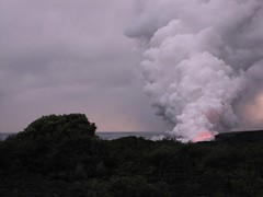
Once you have parked, there is an almost half-mile walk over old lava flows to get to the viewing area near the shore. Reflective pylons and tape are used to try to guide people along the way, which would obviously be difficult to do in the dark. The actual viewing area is predictably disappointing, since it is at least another quarter-mile from the action, with screaming kids and mobs of people jockeying for photo position. All you can really see is a giant plume of steam, with a red glowing area and an occasional explosion of lava into the air. I don't know how to describe it, it sounds boring, but it is really a unique and captivating experience. We were mesmerized for about 45 minutes, until it was dark, and made our way back to the car. It was interesting to see the side of the mountain glowing red in spots, as the lava flowed down from Pu'o 'O'o.

For dinner, we stopped at Kaleo's in Pahoa. It's off the main road in the town center, but not out of the way, and worth the trip. There was a good jazz trio playing, featuring three multi-talented musicians: keyboard/bass (keyboard)/vocals, alto sax/soprano sax/flute, and drums/chairs/walls. The menu was modern and original, the food was fresh and well-prepared, and it was all very reasonably priced. I think I had a grilled ahi entree with rice and tasty grilled veggies, and E had a Thai chicken curry of some sort. For dessert we had a really tasty banana thing where the bananas were fried in tortillas and topped with a cinnamon sauce and vanilla ice cream. Thanks to C+K for the tip, this place was great!

The only downside was that we were still almost 3 hours from "home". It was a long and lonely trip, with little traffic, spotty radio, and a sleeping passenger. Still being a bit jet-lagged, I probably should have gotten some coffee to go, but it didn't occur to me until it was too late. We stopped at least once to walk around the car, to try to stay fresh. It was good to finally get back to the hotel and crash.

This was a good day, but if I had to do it again, I would try to spend at least two days in the park area, or if I were really pressed for time again, try to find a way to stay in Hilo (or one of the small inns in the town of Volcano) so less time is spent driving. I would also love to get a closer view of the active lava flows, which is obviously discouraged by the authorities, but not illegal, as far as I can tell. It seems feasible, as long as you take some reasonable precautions.

Future postings will mostly be shorter than this. I hope. I mean, there's only so much I can write about the Honolulu Airport, but we'll see. Am I blogging or writing my memoirs?

Tuesday, October 20, 2009

Hawaii Diiary: Day 1


I will now proceed to torture you with more Hawaii trip stories that are not actually about Hawaii.

The plan was to depart Boston on Wednesday, September 30, and spend an entire day getting to the Kona Coast on the Big Island. That's a big downside to Hawaii as a destination for east-coasters -- it takes an entire day to get there or back. It explains why so many people on visitor logs were from California and Arizona. We would spend Thursday and Friday on the Big Island and depart Saturday for Kauai, where we would spend another week.

We left our house at 7:45 for a 10:55 flight. That seems early, and we are both kind of insanely paranoid about air travel, but we also had to expect to fight through traffic for up to 90 minutes to get there (I think it ended up being about an hour). I also wanted to leave enough time to park at an off-airport parking lot, since Central Parking at Logan is now a ridiculous $24 per day. Over 12 days, that is a buttload of money. I had read a few good things about PreFlight Airport Parking, only about 2 miles from Logan and almost half the price. The experience was very positive: we arrived at the lot, the van followed us to the car, the very friendly driver helped with our bags and handed us a "newspaper" (USA Today). We were inside the terminal in probably 7 minutes.

The flight boarded on time, but the departure was delayed because the plane's GPS system was malfunctioning. Always a good feeling. I guess we left 15-20 minutes late. Weather was clear for almost the entire flight, so I was able (from my window seat) to track our progress, and we didn't need the GPS. Most of my announcements of our location to Edith were met with smiles and nods. The highlight was when we flew over the Grand Canyon and Page, AZ (pictured above), site of our excellent slot canyon adventure in 2007. It was a good flight; we had nobody in the seat between us. I admit I was That Guy and booked the window/aisle seats, hoping the middle wouldn't get filled.

Landed in LAX with a 2 hour layover, and stalled for a while before looking for dinner. Options were disappointing: generic Tex-Mex (On The Border) and... something inspired by generic Tex-Mex? (Chili's), or Burger King. We chose On The Border. It was unremarkable, but I downed a couple of margaritas so I could maybe sleep on the plane, and they weren't bad.

My plan was thwarted when I was seated next to an older hippie dude named Dennis on the next leg of the trip, and he liked to talk. He was an interesting enough guy, and it was more entertaining than staring out the window at the ocean for 5.5 hours, but I ran out of stuff to talk about after a while, and just wanted some quiet time as it got closer to midnight EDT. Before that, I learned about how he retired to Hawaii, has turned his high blood pressure ("230 over something, been that way all my life") into extra Social Security disability payments, and has managed to live in Hawaii virtually tax free as a result of this status. Good deal if you can get it. He also talked about how he managed to have a car collection of at least 4 or 5 cars, a plantation of cotton (?), mangoes, guavas, papayas, bananas, avocados, macadamia nuts, coffee, the rest of the produce department, and a home with (apparently) about a half-dozen freezers, all on a half acre south of Keauhou. This, after he couldn't afford a houseboat since the slips in the harbor were too expensive.

We finally landed, on time, at about 8PM local time, or 2AM EDT. The Kona airport is kind of weird and feels a little bit like a trip back in time. There are no jet bridges, you climb down the old staircase-on-a-truck and walk across the tarmac to the gate area. Most of the terminal is exposed to the outside, with some basic structures to keep the rain/sun out of some areas, but not much in the way of walls. Under these shelters are wooden benches that constitute the waiting area at the gates. There is one traditional cafeteria-style restaurant. The overall layout might best be described as "rambling", with the gates, checkin and baggage claim areas all stretched along several hundred yards of access road. It took us a while to find the right baggage claim, not realizing we'd have to walk out of the gate area (the "airport" as far as we knew) and down the road. We learned that the Ironman Triathlon was scheduled for October 10, and training had already begun. There were quite a few intense-looking athletes milling about the claim area, surely wondering where their multi-thousand-dollar bikes were.

If you can believe it, the rest of the day only got more dull from here. I had picked up a package from Orbitz for a mid-size rental from Budget, and a "mountain view" hotel room at the Sheraton Keauhou Bay (4/5 stars), for $160/day, which seemed like a good deal at the time. We picked up our rental car (a Pontiac G6 that more than met our needs) without any problems. It was a 15-minute drive to the hotel, and they gave us a "garden view" room, which we learned the next day was basically a free upgrade. We crashed in bed.

Coming up: Volcano! And Brian looks like a drowned rat. (It'll be a few days until it's posted.)

Monday, October 19, 2009

Hawaii Diiary: Prologue


"There's a prologue?!" -E

I think that all nine of our regular readers already know that we recently took our honeymoon, 14 months late, in Hawaii. Edith has put me in charge of blogging the experience because I "care more about details" or something like that. I'm not sure if that was a compliment or not. Anyways, I thought I would go with day-by-day coverage (hopefully, posting one day every few days), and try not to bore you with too many details.

If it's too detailed, you can just look at the pretty pictures! I took almost 600 pictures/videos, so it's (still) going to take me a few days to prepare each batch for each entry. All of my photos were taken with my new Canon PowerShot SD960 point-and-shoot. I can't post all of the interesting ones here, for size and aesthetic reasons, so I recently started a Flickr account that will have all the good photos from this trip.

I had a lot of reservations about Flickr as a viewer. I wasn't too fond of the photostream interface, although my recent discovery of collections and sets made me happier. But once I set up an account, I liked the organizer tools, and $25/yr for unlimited storage (think backups) seemed like a fair deal. Also, many of my friends are using it, so I get to feel like I'm doing something like "social networking" without being social, or networking. Later, after these trip reports are all done, I will probably upload a bunch of older stuff from my archives, so don't be surprised if you see a bunch of random old crap in my photostream.

Edith also has a Flickr account. She took some pictures on this trip too, but not as many as I did. I don't know what she plans to do with them, but she says she'll put links to both our galleries on the left sidebar.

This photo was me attempting to be arty and patriotic or something, while waiting around in Logan Terminal B. I don't think I succeeded, but I like to have pictures on my bloggings. It was hard to get the timing right on this shot, when I could only hear (not see) the planes accelerating before they came into view.

Sunday, October 18, 2009

Womb with a view

I guess we have a problem posting these pictures promptly, but whatever. Here's Spawn at 18 weeks, which was, uh, about 4 weeks ago. In both images, it's looking up and to the right again. The lighter blob in the middle is its face, with it's fist up by its forehead. The clubby thing on the right side is its leg. You also get a closeup of its head and shoulders, presumably because the ultrasound technician wanted to highlight its enormous brain, which it clearly gets from its mother, if not both of us.


Hello!

Hi! It's me! I will give you a brief interlude from the hiking reports. Also, I'm going to annoy Brian by messing up his chronological record. I thought I would give you a spawn update (which may be followed by a short rant, but you'll thank me later when you don't say the wrong thing to me and piss me off).

Here is a picture of me (headless) at 22 weeks:


It isn't Brian's fault that it is a bad picture, or that I'm headless. I'd just washed my hair and I kind of looked like a drowned rat, so I cut my own head off.

Now for the rant/advice. I do not appreciate people telling me either (1) that I'm getting, "chubby" or (2) that I don't look 22 weeks pregnant. In other words, don't tell me I'm either big or small it's annoying. Actually, to do a little scolding, I happen to believe that commenting on someone's weight is kind of rude in any case and that includes comments such as, "I don't know how you eat like that and stay so skinny". Many people believe that is a compliment, but there are actually a whole bunch of subtle messages packed into such a statement. Anyway, I'm not going to get into it. Just please respect my wishes and don't talk about my weight, OK? That is all. Thank you.

Saturday, October 17, 2009

Mount Garfield

Date: September 20, 2009
Crude map of route


Another perfect weather day. If I remember correctly, we were planning to do some part of the Presidential Range, but bailed because we ended up sleeping in until 8 o'clock or something. We almost bailed on hiking altogether, but the weather looked too good, so we picked something slightly closer to home: Mount Garfield.

For some reason I had a hard time understanding the notes in the White Mountain Guide regarding where the trailhead actually was, and where to park. Gale River Road makes a loop, with the trailhead closer to the western end. When we turned off US 3 to follow the road to the trailhead, the gate was closed with a sign saying ROAD CLOSED. There was only one other car in the parking lot, which was also surprising. Something was obviously up. It was after noon at this point, so we decided to just park there and hike the 3/4 mile up the road on foot, rather than try to drive down to the other end of the loop and go in that way, not knowing what the condition of the road was like. We were in a Corolla, after all.

Well, it turns out that the reason the road is closed is due to a number of bridge washouts that occurred in summer 2008. The washouts are pretty severe, and are obviously taking a while to rebuild. There were three washouts, one of which is shown here. It looked like one of the washouts actually occurred at the location of a previous washout -- there was fresh riprap and grass on one approach to the bridge, but of course, it was the other side that washed out.

Since it hadn't rained in a while, it wasn't too difficult to cross the river on foot using rocks. After that, we eventually reached the real trailhead, with a dozens of cars parked there. I guess access from the other end was OK after all. Anyways, the Garfield Trail is a pretty easy ascent to the summit, thanks to half a dozen switchbacks in the last couple miles. The grade is never more than moderate, until the last 1/4 mile up to the summit on the Garfield Ridge Trail. Once you reach the summit, you're treated to excellent views of the Pemigewasset Wilderness. I'll treat you to a picture of me this time.

Total distance was about 11 miles round trip (including the 1.5 miles on Gale River Road), which we completed in about 5 1/2 hours. Like Mount Osceola, this is another trip that is doable by people of almost any ability, although Garfield is a little bit longer (even when departing from the actual trailhead).

Tuesday, October 13, 2009

Hiking briefs

As in, trip reports. Although, I do have some hiking underwear too. For some reason, I feel I have to bang these out before posting any newer pictures from our more recent trips (like Hawaii), so here we go. (Also, I have to sort through the 600+ pictures I took.)


Mt. Pierce and Mt. Eisenhower: August 16, 2009

Crude map of route

This was about 9 miles, via Crawford Path with side trip to Mizpah Springs Hut on the way home. I think it took us about 6 hours. Most of Crawford Path is a steady, moderate climb. You can skip the hut unless you need water, saving probably a half mile, and the side loop to the hut has one steep section. This was our first anniversary! The first image (one of many where Edith is looking impatient) is the view of the ridge from Mt. Pierce to Mt. Eisenhower and on to Mt. Washington.

The other photo was taken for us by another hiker on the Eisenhower summit. You can see, it was hot and hazy that day. We almost did a lamer hike that day because it was so hot, but this turned out to be a good choice. The sun was beating down hard, but it was in the 70s on the summits.


Mt. Osceola and East Osceola: August 30, 2009

Crude map of route

This is relatively easy for anyone, even with limited hiking skills. It's about 6.5 miles round trip, via Osceola Trail from Tripoli Rd. The parking area is at Thornton Gap. It's paved from Waterville Valley side, and the pavement ends at the parking area, so go in from the east. First half mile of the trail is a little rough (rocky) but the rest of the climb is pretty easy, wide and sandy gravel for a lot of the way. At the top there are no 360-degree views but there are several viewpoints. The best is an open rock ledge looking north to southeast. As you can see, we had a mix of clouds and sun that day. If you are not interested in peakbagging, you can turn around here, but if you are trying to complete the NH 48 4000 footers, you have to go over to East Peak (second photo). There are a couple of very steep parts on the ridge, but it took us less than an hour between them. The east peak is wooded and has no views, much to E's disappointment, so it's useful only for checking the box on your list. That's me sitting on the cairn marking the summit. The round trip was about 5 hours and we took a long lunch break and several other breaks.


Cannon Mountain and Kinsman Ridge: September 6, 2009

Crude map of route


This long loop trip took us 9 hours and we were trying not to waste too much time. The weather was perfect, as you can see. We saw at least to Jay Peak about 70 miles away. I thought maybe Mt. Marcy in the Adirondacks was out west, but I guess it was more likely to be Mansfield. Didn't try to take many good pictures from Cannon, since the summit is overrun with people who took the tram and it makes you want to just get off. :) The picture of Franconia Ridge is the view from North Kinsman, where there is an open ledge looking east (South Kinsman has a more 360-degree view). Cannon is on the left (with the tower on top) and the trail we took follows the ridge coming towards us there. Mt. Lafayette and the Franconia Ridge should be obvious in the right half of the photo. Mt. Washington (I think... maybe it's Mt. Adams) is just peeking over the left shoulder of Lafayette. The lake in the middle of the photo is Lonesome Lake, and there is an AMC hut there that is open year-round (self-service in winter). The photo from the lakeshore shows the view from near the hut, looking up towards Cannon. There is also a great view of Lafayette from there.

We were originally going to depart from the Lafayette Campsite and make a loop up Cannon, across the ridge, and back down by the hut. However, the campsite parking areas were totally overflowing with cars (onto the highway) so we went further up to the Cannon Mountain Tramway exit, and took the Kinsman Ridge trail up the NE face of Cannon instead. This was a pretty good plan, but after traversing the ridge (and the 5 or 6 different humps along the way), I didn't want to go backover all those humps again. We went down to the hut and out to the highway, and followed the Pemi Trail back along the highway (yuck) to the tramway.


That covers 3 out of 4. Just a couple other items coming soon, then we can get down to Hawaii business.