When taking an arm's-length self-portrait, remember to zoom out first.
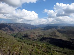 Waimea Canyon is one of Kauai's many natural wonders. Stretching for over 10 miles from north to south, and over 3500 feet deep, it's highly reminiscent of the Grand Canyon, just not as big. Waimea Canyon State Park lines the western edge of the canyon, and at the north end, Koke'e State Park stretches another 4 or 5 miles to the north and east, covering the plateau at the top of the Na Pali coastline ridge. Unfortunately, with the steep mountain range along the Na Pali Coast preventing direct travel by car, we had to nearly circumnavigate the island to get there -- a 2 hour drive (over 70 miles) just to travel 11 miles, as the crow flies.
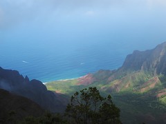 We made our way toward the end of the road, which is home to the Kalalau Beach Lookout and the trailhead for the swamp loop. The lookout was beautiful, it was sunny at the shoreline and and we were just under the cloud deck that formed as the moist ocean air was forced up the valley wall. You could actually watch this happening. As we proceeded to the trailhead for the Alaka`i Swamp loop, we ascended into the clouds and everything was completely socked in. The parking lot at the end was also completely full, and overflowing well down the road. We decided to turn around and take the coastal loop.
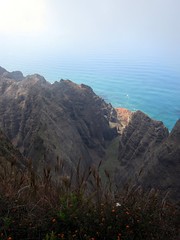 As we parked at the other trailhead and started down the trail, it continued to get more cloudy. It was clear that if we didn't hurry, we weren't going to see anything, and a hiker coming the other way told us it was clouding up fast. We booked down the 3 mile Awa`Awapuhi Trail in just over an hour, and got to the viewpoint with about 5 minutes to spare. We only just barely got to look down into the Nu`alolo Valley before our viewpoint was also completely fogged in. There was nobody else there, and it was really rather serene and tranquil -- except for the helicopters buzzing around us every 10 minutes. We ate our lunch as the mist enveloped us, while listening to the helicopters zooming in and out of the valleys below.
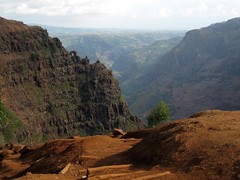 Sure enough, it was, and we followed a combination of trails to a cliff overlook, and the top of Waipo'o Falls. After following a gravel road for a while, we used a combination of the Cliff, Black Pipe, and Canyon Trails, to get to the falls. The route is very interesting, with the first section through the woods and then the next session along the top of an open ledge, with excellent views of the canyon. These 800-foot falls are visible from many of the Waimea Canyon lookouts, but the only trail goes across the top. Before the stream makes its plunge over the falls, it wends through a lush and tropical garden full of ginger plants. The flowers and fragrances were lovely, even if the plants are considered invasive and are taking over the whole area. There is not much to see of the actual falls from the top, but there is a great view of an interesting natural rock formation on the shoulder of the Ka`ou ridge.
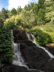 Since it wasn't obvious where to cross the stream, and it was going to be getting dark soon, we decided to head home. Rather than stopping for dinner on the way, we drove home first to get cleaned up. For dinner we tried Pau Hana Pizza in Kilauea, next door to the Lighthouse Bistro and recommended in several guidebooks. There were a couple of tables outside, but not much of a dining area, so we decided to get takeout and bring it back to the condo. The menu had some interesting flavor combinations, and the pizza was generally pretty good, but kind of expensive and not terribly memorable.
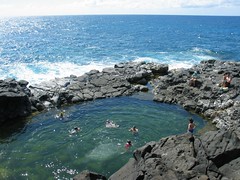 Among the places suggested by the lady at the snorkel shop for first-timers was Queen's Bath, a tidal pool not far from our condo (not my photo -- borrowed from Flickr). Queen's Bath seems like a good place to get swept out to sea and drown in the winter, but in the summer at low tide, the pool is clear and calm. The snorkel lady described it as a "fishbowl", uninteresting for advanced snorkelers but an decent place to get started. The pool is down another steep dirt path that was very muddy, since it had been raining for a few days. When we arrived there was nobody in the pool, but a few people standing around it warily, wondering how to get down to the edge and whether to obey the numerous warning signs. Eventually one intrepid swimmer blazed the trail for the rest of the group.
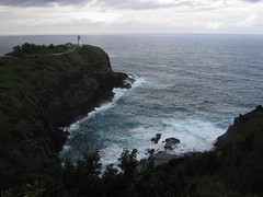 We planned out a few things to do on the way there during the afternoon, since the Kauai location is in Poipu, on the south side of the island, an hour from our condo. First on the list was a return to the Kilauea Lighthouse, which was open until 4 PM. The lighthouse marks the northernmost point in Hawaii and was operational from 1913 to 1976, when it was replaced with an automatic beacon. It is part of the Kilauea Point National Wildlife Refuge, serving primarily as a bird sanctuary for a variety of land and sea birds. There are hundreds of birds, of at least a dozen different species, that regularly circle around the cove next ot the lighthouse, including boobies, albatrosses, shearwaters and nene.
 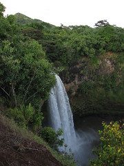 After the lighthouse we stopped at the 'Opaeka'a Falls overlook, which was nice enough but not very exciting. Then we made our way to Wailua Falls overlook, which is several miles up a side road, through an old sugar plantation. You can get closer to these falls, and I thought it was a more scenic area than 'Opaeka'a Falls. There was also some very interesting sun/cloud formations in the west, as the sun started to set. Since we were reasonably well-dressed for dinner, we didn't try to make our way down to the base of the falls using the "illegal" path.
 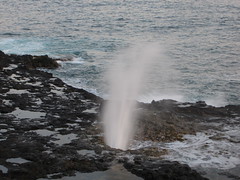 After we had our fill of the waterfalls, we continued to Poipu, but we were still at least an hour early for our 7:30 reservation. Our map referenced something called Spouting Horn Blowhole, and we went to check it out literally just as the sun was setting. The blowhole is kind of neat, spraying into the air with each large wave.
 We stalled for long enough that we felt we could go to the restaurant and have a cocktail at the bar before our reservation for dinner. Merriman's Poipu is in a brand new
 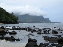 We started off Sunday wondering if we could find the nearest beach to our condo. There was no direct beach access from our condo area, and the nearest beach we saw mentioned in any guides or maps was Hideaways beach. We decided that we just wanted to walk and scope it out, rather than spend the morning there, but I don't remember why. It ended up being a 15 or 20 minute walk from our condo, and hard to find since the access was hidden at the end of a parking area within another condo complex. Only a "private beach access" sign gave any sign that it was there.
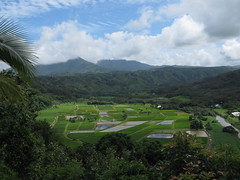 After returning home and eating lunch, we tried to go to Limahuli Gardens, which is on the northwest corner of the island, near the end of the road. The road (Route 560) is mostly narrow and winding, with at least a half dozen one lane bridges between Hanalei and the end. It's only 7 miles and about 15 minutes to drive, but it feels longer. After finally getting to the gardens, we found out they were closed on Sundays. D'oh! Should have called first.
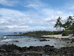 Saturday we were to leave the big island for Kauai. We'd been in the tropics for three days and hadn't hit the beach yet, and we had a little time before our flight, so we tried to find a beach somewhere north of the airport. There were several turn-offs from the highway that looked promising, if we had more time or a 4x4 instead of a sedan, but the one we tried to get to was going to take too long. Recommendation: if you want to go to obscure beaches or other remote spots anywhere in Hawaii, spend the extra $$$ on a Jeep or other similar vehicle. You can walk or crawl your sedan in many cases, but it'll be easier if you have the right car. We turned around and ended up driving all the way to Waikoloa, where we eventually got to the "beach" at the Waikoloa Hyatt Resort. The Hyatt seemed like a nice place, but not really our thing, a little too Disney World-y.
 Thanks to the wonders of modern airline travel, we had to waste a huge chunk of our day traveling, even though it's only about 250 miles between Kailuha-Kona and Lihue airports. Between the rental car return, check-in, security charades, flights, layovers and rental car procurement at our arrival, it took almost five hours. We flew on Mokulele Airlines (who?), a small Hawaii inter-island carrier that had recently (2008) gotten into serious regional jet passenger service. Their corporate history was complicated, but I was eventually convinced that they were legit. They got positive reviews on the web, they offered flights at the time I wanted, and for the same price as everyone else ($99). The flights were completely uneventful, which is perhaps the highest praise you can give an airline these days. Bonus points for attempting to serve me a coffee on the second leg between Honolulu and Lihue, where we spent about 20 minutes in the air. Mokulele subsequently merged with go! Airlines right after we left, who has mixed reviews, so who knows what the service will be like in the future. Doesn't matter much to me anymore, though. By the way, I love the big green courtyards inside the Honolulu Airport.
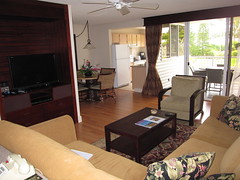 After all of this, we eventually left Lihue Airport for our condo in Princeville, a destination on the north shore of the island that blurs the line between town and real estate development. It's about 45 minutes from the Lihue airport. My parents were generous enough to give us a week-long condo rental for our honeymoon, courtesy of RCI and our timeshare weeks in Hilton Head that we no longer use. I won't go into the RCI swapping shenanigans that resulted in our landing in Princeville, but we ended up with a unit at The Cliffs at Princeville for the week. We were assigned to a second-floor condo in building 3, on the mauka (mountain/non-seaward) side of the property, which was recently renovated. The interior was very nice inside, except for a severe lack of lighting at night. We wondered if a table lamp was missing or something. The rest of the grounds at The Cliffs were very nice -- decent pool, ocean view (if you walk across the property) and the usual set of amenities for a complex of this type. The staff was friendly, especially the overly enthusiastic Activities Manager, and we were very happy with the accommodations.
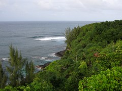 We hit the local supermarket to stock up on provisions for the week, and after looking at a couple of local dining options, ended up at a completely generic and unremarkable bar and grill at the Princeville shopping center. I can't even remember the name. I don't know if it was allergies or jet lag or something I picked up from the planes, but I was not feeling so great, and we weren't feeling very adventurous for dinner. We crashed right after that.
 In early Hawaiian times, warriors who were defeated in battle, or others who broke kapu (ancient laws), could find refuge in the Pu'uhonua, which is an area surrounded by a Great Wall and protected by the spirit of Chief Keawe`ikekahiali`i o kamoku (his friends called him Keawe). Consider that battles were to the death in olden times, so if you were losing, you ran for your life. The kapu were a set of laws forbidding various activities involving the Chief, or having some other spritual bent, and violating the kapu also meant immediate death. In either case, if you were able to evade the angry mob coming after you long enough to get to the Pu'uhonua (either by scaling the 10-foot high and 17-foot wide wall, or by swimming across the bay to reach the beach), you would be safe, since the Pu'uhonua was considered to be sacred ground. You would then be absolved of your sins by a priest and allowed to leave freely. It's not clear how the angry mob was supposed to know that you were saved, but whatever.
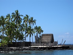
 Next to the Pu'uhonua are the Royal Grounds, used by a series of chiefs and kings several hundred years ago. The grounds originally housed a bunch of thatched buildings, freshwater fish ponds (for food), and the royal canoe landing. Many of the buildings are now gone, although the National Park Service has recreated several of them in full size or scale models. The royal boat ramp was popular with green sea turtles. Not sure if the turtles were prosecuted for breaking kapu in ancient times, but the canoe landing was traditionally reserved for the chief only. Everyone else had to use a different one up the coast.
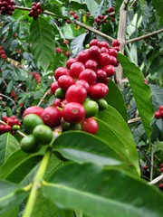 Kona is well-known for its coffee, and after lunch we visited the Kona Blue Sky Coffee Company in Holualoa. The Twigg-Smith family has been growing all their own coffee on 400 acres for several generations. We watched an informational video while guzzling lots of free samples (B only), and the shop manager gave us a tour of their garden near the visitor's center. Unfortunately, there was not much of a legitimate tour going on while we were there -- no visiting the actual orchards, or activity in the roasting room. The coffee is quite good, though. Holualoa is also home to a collection of art galleries, which we spent an hour or two strolling through. A few were closed for some reason, maybe because there weren't many shoppers around on his Friday afternoon, either.
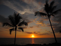 As I mentioned in an earlier posting, we were quite pleased with the Sheraton Keauhou Bay hotel. The location, right on the water, can't be beat, except if they had a sand beach and reef for snorkeling on site. Our room was reasonably large and recently updated. The bar/lounge was a comfortable place for some cocktails, open to the outside, with several levels of seating so that everyone can see out to the ocean from their table or couch. There is a patio area attached (where weddings probably occur), and there is manta ray viewing from the patio after dark. The hotel shines spotlights into the water, which attracts extra algae blooms, which attract the rays. We weren't able to see any, but there were several boats full of divers exploring the area after dark, so I assume it's working.
 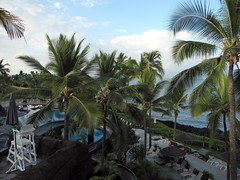 We woke up on Thursday to find that our "garden view" hotel room actually overlooked the pool, with the ocean in the distance. The hotel's two pools were large and connected, with grottos, kiddie beaches, and a water slide. Very impressive. Unfortunately, we didn't have time to enjoy it. More on the hotel in a later entry.
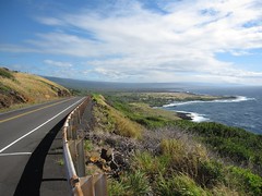 After grabbing coffee and a muffin, we left for Hawaii Volcanoes National Park, a third of the way around the island on the south side. Even though it was only 80 miles, it would take about two hours to drive there. The road is only two lanes, with some towns and winding sections. We were delayed at the start by the traffic jam going into the school, but made pretty good time once we got through the first 30 slow miles. There are some very scenic parts of this drive, especially northeast of Naalehu, and not much else.
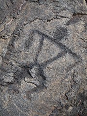 We first drove most of the way to the end of the Chain of Craters Road, and the weather cleared up nicely as we approached the ocean. There is a cliff along the way, which is covered with the remnants of lava flows from the 1970s. We stopped at the Pu'u Loa Petroglyphs. Here, each generation of the ancient Hawai'ians would carve symbols in the lava rocks and deposit the piko (umbilical cord) of their kids in the pukas (holes), hoping that the spirits would bless their child with a long and prosperous life. This is supposedly one of the largest and most concentrated areas of petroglyphs in Hawaii.
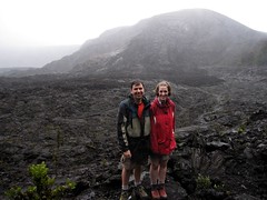 We joked with the park ranger about how great a day it was for a hike, and he agreed (seriously) that it was a better than average day, since it wasn't a torrential downpour. Like I was saying, I guess it rains a lot there. We did get pretty wet over the next few hours, but the ranger still wove some good stories. It eventually stopped, and even cleared up a bit, as we entered the crater for the return half of the loop. The ranger did have some interesting talks, explaining the different types of volcanoes found around the world, the difference between indigenous and endemic species in Hawaii, and describing the Kilauea Iki eruption of 1959, where lava spewed hundreds of meters in the air. Nothing that exciting was happening on the day we were there, but we did get to walk on the surface of an active volcano, and the steam vents were still satisfyingly steamy.
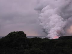 Once you have parked, there is an almost half-mile walk over old lava flows to get to the viewing area near the shore. Reflective pylons and tape are used to try to guide people along the way, which would obviously be difficult to do in the dark. The actual viewing area is predictably disappointing, since it is at least another quarter-mile from the action, with screaming kids and mobs of people jockeying for photo position. All you can really see is a giant plume of steam, with a red glowing area and an occasional explosion of lava into the air. I don't know how to describe it, it sounds boring, but it is really a unique and captivating experience. We were mesmerized for about 45 minutes, until it was dark, and made our way back to the car. It was interesting to see the side of the mountain glowing red in spots, as the lava flowed down from Pu'o 'O'o.
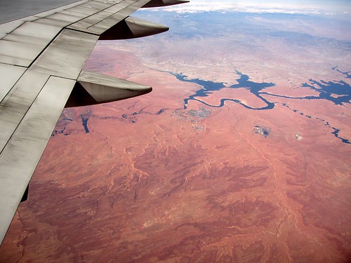


Another perfect weather day. If I remember correctly, we were planning to do some part of the Presidential Range, but bailed because we ended up sleeping in until 8 o'clock or something. We almost bailed on hiking altogether, but the weather looked too good, so we picked something slightly closer to home: Mount Garfield. For some reason I had a hard time understanding the notes in the White Mountain Guide regarding where the trailhead actually was, and where to park. Gale River Road makes a loop, with the trailhead closer to the western end. When we turned off US 3 to follow the road to the trailhead, the gate was closed with a sign saying ROAD CLOSED. There was only one other car in the parking lot, which was also surprising. Something was obviously up. It was after noon at this point, so we decided to just park there and hike the 3/4 mile up the road on foot, rather than try to drive down to the other end of the loop and go in that way, not knowing what the condition of the road was like. We were in a Corolla, after all.
 Well, it turns out that the reason the road is closed is due to a number of bridge washouts that occurred in summer 2008. The washouts are pretty severe, and are obviously taking a while to rebuild. There were three washouts, one of which is shown here. It looked like one of the washouts actually occurred at the location of a previous washout -- there was fresh riprap and grass on one approach to the bridge, but of course, it was the other side that washed out.
 Since it hadn't rained in a while, it wasn't too difficult to cross the river on foot using rocks. After that, we eventually reached the real trailhead, with a dozens of cars parked there. I guess access from the other end was OK after all. Anyways, the Garfield Trail is a pretty easy ascent to the summit, thanks to half a dozen switchbacks in the last couple miles. The grade is never more than moderate, until the last 1/4 mile up to the summit on the Garfield Ridge Trail. Once you reach the summit, you're treated to excellent views of the Pemigewasset Wilderness. I'll treat you to a picture of me this time.
Total distance was about 11 miles round trip (including the 1.5 miles on Gale River Road), which we completed in about 5 1/2 hours. Like Mount Osceola, this is another trip that is doable by people of almost any ability, although Garfield is a little bit longer (even when departing from the actual trailhead).
  | Mt. Pierce and Mt. Eisenhower: August 16, 2009 Crude map of route This was about 9 miles, via Crawford Path with side trip to Mizpah Springs Hut on the way home. I think it took us about 6 hours. Most of Crawford Path is a steady, moderate climb. You can skip the hut unless you need water, saving probably a half mile, and the side loop to the hut has one steep section. This was our first anniversary! The first image (one of many where Edith is looking impatient) is the view of the ridge from Mt. Pierce to Mt. Eisenhower and on to Mt. Washington. The other photo was taken for us by another hiker on the Eisenhower summit. You can see, it was hot and hazy that day. We almost did a lamer hike that day because it was so hot, but this turned out to be a good choice. The sun was beating down hard, but it was in the 70s on the summits. |
Mt. Osceola and East Osceola: August 30, 2009 Crude map of route This is relatively easy for anyone, even with limited hiking skills. It's about 6.5 miles round trip, via Osceola Trail from Tripoli Rd. The parking area is at Thornton Gap. It's paved from Waterville Valley side, and the pavement ends at the parking area, so go in from the east. First half mile of the trail is a little rough (rocky) but the rest of the climb is pretty easy, wide and sandy gravel for a lot of the way. At the top there are no 360-degree views but there are several viewpoints. The best is an open rock ledge looking north to southeast. As you can see, we had a mix of clouds and sun that day. If you are not interested in peakbagging, you can turn around here, but if you are trying to complete the NH 48 4000 footers, you have to go over to East Peak (second photo). There are a couple of very steep parts on the ridge, but it took us less than an hour between them. The east peak is wooded and has no views, much to E's disappointment, so it's useful only for checking the box on your list. That's me sitting on the cairn marking the summit. The round trip was about 5 hours and we took a long lunch break and several other breaks. |    |
  | Cannon Mountain and Kinsman Ridge: September 6, 2009 Crude map of route This long loop trip took us 9 hours and we were trying not to waste too much time. The weather was perfect, as you can see. We saw at least to Jay Peak about 70 miles away. I thought maybe Mt. Marcy in the Adirondacks was out west, but I guess it was more likely to be Mansfield. Didn't try to take many good pictures from Cannon, since the summit is overrun with people who took the tram and it makes you want to just get off. :) The picture of Franconia Ridge is the view from North Kinsman, where there is an open ledge looking east (South Kinsman has a more 360-degree view). Cannon is on the left (with the tower on top) and the trail we took follows the ridge coming towards us there. Mt. Lafayette and the Franconia Ridge should be obvious in the right half of the photo. Mt. Washington (I think... maybe it's Mt. Adams) is just peeking over the left shoulder of Lafayette. The lake in the middle of the photo is Lonesome Lake, and there is an AMC hut there that is open year-round (self-service in winter). The photo from the lakeshore shows the view from near the hut, looking up towards Cannon. There is also a great view of Lafayette from there. We were originally going to depart from the Lafayette Campsite and make a loop up Cannon, across the ridge, and back down by the hut. However, the campsite parking areas were totally overflowing with cars (onto the highway) so we went further up to the Cannon Mountain Tramway exit, and took the Kinsman Ridge trail up the NE face of Cannon instead. This was a pretty good plan, but after traversing the ridge (and the 5 or 6 different humps along the way), I didn't want to go backover all those humps again. We went down to the hut and out to the highway, and followed the Pemi Trail back along the highway (yuck) to the tramway. |